


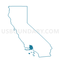
Voting District 10080, Ventura County, California
About
Outline

Summary
| Unique Area Identifier | 546045 |
| Name | Voting District 10080 |
| County | Ventura County |
| State | California |
| Area (square miles) | 12.39 |
| Land Area (square miles) | 12.39 |
| Water Area (square miles) | 0.00 |
| % of Land Area | 99.99 |
| % of Water Area | 0.01 |
| Latitude of the Internal Point | 34.41613260 |
| Longtitude of the Internal Point | -119.41571780 |
Maps


Graphs
Select a template below for downloading or customizing gragh for Voting District 10080, Ventura County, California


Neighbors
Neighoring Voting District (by Name) Neighboring Voting District on the Map
- Voting District 10021, Santa Barbara County, CA
- Voting District 10085, Ventura County, CA
- Voting District 10095, Ventura County, CA
- Voting District 10190, Ventura County, CA
- Voting District 10305, Ventura County, CA
- Voting District 10345, Ventura County, CA
- Voting District 10375, Ventura County, CA
Top 10 Neighboring County Subdivision (by Population) Neighboring County Subdivision on the Map
- Ventura CCD, Ventura County, CA (111,889)
- Ojai-Mira Monte CCD, Ventura County, CA (27,784)
- Carpinteria CCD, Santa Barbara County, CA (17,718)
- Los Padres CCD, Ventura County, CA (819)
Top 10 Neighboring Unified School District (by Population) Neighboring Unified School District on the Map
- Ventura Unified School District, CA (118,441)
- Ojai Unified School District, CA (21,739)
- Carpinteria Unified School District, CA (17,930)
Top 10 Neighboring State Legislative District Lower Chamber (by Population) Neighboring State Legislative District Lower Chamber on the Map
Top 10 Neighboring State Legislative District Upper Chamber (by Population) Neighboring State Legislative District Upper Chamber on the Map
Top 10 Neighboring 111th Congressional District (by Population) Neighboring 111th Congressional District on the Map
Top 10 Neighboring Census Tract (by Population) Neighboring Census Tract on the Map
- Census Tract 17.06, Santa Barbara County, CA (4,693)
- Census Tract 10.01, Ventura County, CA (2,488)
- Census Tract 12.06, Ventura County, CA (941)
- Census Tract 1, Ventura County, CA (819)